Strathcona
Strathcona arose when the first railway north from Calgary terminated at the south river bank, much to the chagrin of the town of Edmonton on the north side, and to the delight of southsiders who quickly formed a burgeoning rival community.
Strathcona arose when the first railway north from Calgary terminated at the south river bank, much to the chagrin of the town of Edmonton on the north side, and to the delight of southsiders who quickly formed a burgeoning rival community.
The south banks of the North Saskatchewan River across from where the Alberta Legislature Buildings now stand is the traditional territory of the Sarcee, or Tsu T’ina First Nation of the Blackfoot Confederacy, and the Strongwood Cree First Nation both centred around Beaver Hills. This area also became home to Chief Papaschase and his people when they arrived in the mid-1850s. When peace was established between these parties in 1871 the local Métis and white newcomers began to feel secure enough to settle on the area, likely for the first time. William Bird, for example, farmed and built a flour mill at Mill Creek in 1874.
Papaschase signed Treaty 6 in 1877 and a reserve of about 60 square miles was set aside for him and his people covering what is now the river valley and south Edmonton, but he was forced to make one concession after another until his band was dispersed entirely by 1894. A preliminary survey by the new Dominion of Canada in 1878 showed a substantial Métis and Indian majority on both sides of the North Saskatchewan. However, according to Randy Lawrence, "the 'better-connected' and less 'working-class' northside Edmonton Métis were generally able to obtain formal title to their riverlots and... sell their valuable real estate at something approaching fair market value. On the southside, however, in future Strathcona... the 'more Native' and 'working class' Métis families here basically just 'disappeared' by 1882 without any clear compensation.” Dominion Land Surveyors officially demarcated local property in 1882. On the south banks of the river, river lots ran essentially from Hawrelak Park to about Connor’s Road. The remaining area was divided into grid-based sections. John Walter and Lawrence Garneau retained river lot property they had homesteaded previously. Much of the remainder of the area that is now Strathcona was taken up by new residents.
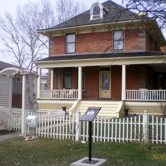
When a rail line was brought north in 1891, the Calgary and Edmonton Railway Company (C&E) resisted pressure to bring the railway to Edmonton - reasonably citing the high cost of a bridge across the North Saskatchewan River - and instead brought the end-of-steel to the south banks and established their own townsite of South Edmonton, managing to capitalize on land sales in the process. The C&E erected a railway station - (a replica of which still stands on 86 Avenue), an engine house, coal shed, water tank and the Hotel Edmonton. Later renamed the Strathcona Hotel, this structure is the oldest wood framed commercial building in Strathcona. The commercial and civic centre developed along Whyte Avenue and Main (104th) Street with roads graded courtesy of the C&E (and much primarily to their advantage). Residents like Arthur McLean, whose 1896 Queen Anne style home is a Registered Historical Resource, began living in the area north of Whyte Avenue.
Continued rivalry with their neighbour across the river prompted southsiders to incorporate as a town with a self-defining name in 1899. The town voted to be called Strathcona, after HBC and CPR magnate Donald Smith who took the name Lord Strathcona and Mount Royal when he returned to Britain in the 1890s. The next eight years was marked by the investment of the new town council: street improvements, concrete sidewalks, and public works including lights, telephone lines, water, and sewage systems. In 1902 council passed a fire prevention law enforcing the use of brick in new developments or renovations. The McKenzie residence, Duggan Street School (now Queen Alexandra), the Gothic Revival-styled Knox Church, and the Dominion Hotel - a lavish wooden façade on a plain brick structure - are remnants of this era.
In 1907 Strathcona was incorporated as a city in the midst of dynamic growth. Its boundaries expanded west and south and the city financed impressive public buildings, a market, fire hall, and new parks and boulevards. A street railway connected the so-called twin cities of Edmonton and Strathcona via the Low Level Bridge, and the federal government even invested in a post office and armoury. The two cities became more enmeshed, however, and to spite a contentious past, the City of Strathcona embraced amalgamation with Edmonton in 1912.
After 1912 growth slowed and development shifted to the north side of the river. Lawrence Herzog notes that this is “why Strathcona… boasts an amazing stock of vintage buildings - a virtual time capsule of the community’s early, vibrant years.”
The area, now defined by the North Saskatchewan River, Whyte Avenue, Mill Creek Ravine and 107 Street, has had to fight - sometimes fiercely even - to retain its character and composition. Over half its buildings were constructed between 1913-1915, and 1946-1950 - mostly single family homes and commercial structures. However the area west of 99 Street was rezoned in the 1960s to allow for walk-up apartments, and a development boom in the next two decades brought traffic concerns and high-rises, and the fear of losing integral historic structures. In 1969 residents of Strathcona united to fight a freeway cutting through Whyte Avenue and over Mill Creek Ravine. Similar battles for heritage preservation paid off however, and in 2007 Alberta declared a five-block area around Whyte Avenue a Provincial Historic Area.
Details
Sub Division Date
TBA
Structures
Bard Residence
Duggan Residence
Gerolamy Residence
Holy Trinity Anglican Church
Margaret Martin Residence
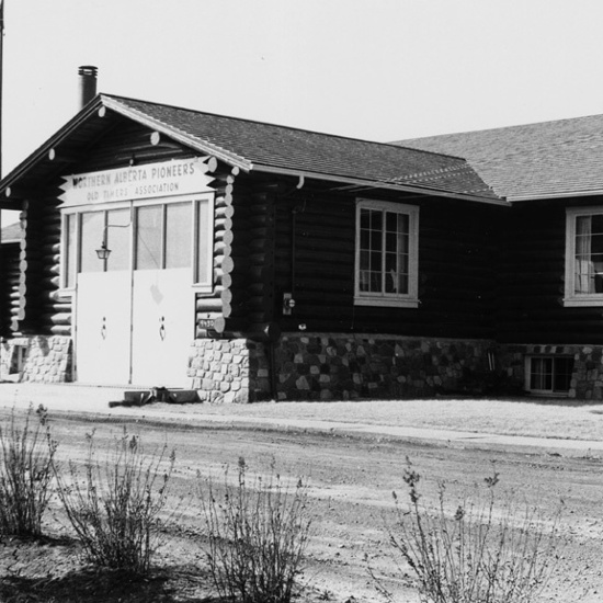
Old Timers' Cabin
Sache House
Architects
P. Leonard James
L. Keith
Arthur Whiddington
Henry Whiddington
Hobart Dowler
Herbert Alton Magoon
Unknown
